
Catton Park History
Introduction
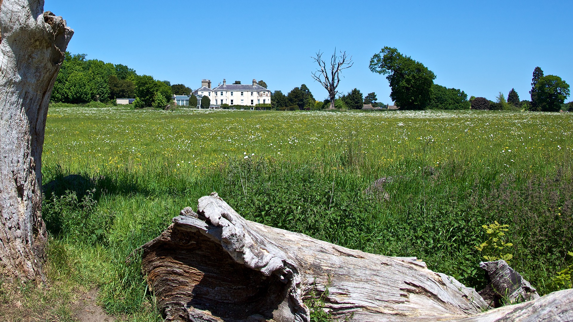
The development of the area now known as Catton Park was carried out over a period of a hundred years from the 1770s onwards and was the work of successive owners of the Catton Hall estate of which it formed a part. Although Catton Hall is no longer in the same ownership as Catton Park, the history of the two is inextricably linked as that of a mansion in a parkland setting.
The Catton Hall estate was not unusual in being formed as a place of occasional residence for the business elite of the city, and Norwich had, by the late 18th century, a ring of such residences1.
Many of these were a 'house in the country' with up to ten acres of grounds, whilst others like Catton Hall had larger grounds which allowed for that most desirable of landscape features - a park. So important was the park to the owners of Catton Hall that it was enlarged twice, firstly in 1788 and again in 1856, by diverting public roads, a costly business not lightly undertaken. However the Catton Hall estate differed from most of the businessmen's residences with parks, in that it also included a larger agricultural acreage than was usual for estates of this type. In 1835 it amounted in total to some 600 acres and extended into the adjoining parishes to the west and east of Catton. The ownership of this land enabled the second park enlargements to proceed without the problem of the acquisition of additional land.
Before the building of Catton Hall
The manor of Catton c.1000 acres was given by the Crown to the Benedictine Priory established
in Norwich when the cathedral was built in the early 12th century. After the Dissolution of the
Monasteries in the mid-16th century the manor passed to the Dean and Chapter of Norwich
Cathedral2.
The first map of Catton in the 18th century is a copy of one dated 1746 entitled 'A Map of Mr
Lincoln's Estate at Catton3. This estate consisted of land not only in Catton but in the adjoining
parishes of Sprowston, St Faith's and Hellesdon, and was probably in excess of a thousand acres.
This would indicate that the Dean and Chapter of Norwich Cathedral had by the mid-18th century
leased or sold a substantial acreage of their holdings in Catton and the adjoining parishes. The
area which was to become Catton Hall and its park lay on the eastern extremity of this map south
of the Manor House and parish church of Catton. It comprised a narrow triangle of land bounded
by roads. Field boundaries were not included on the map.
1W Faden. A New topographical map of the county of Norfolk 1797.
2Broadland District Council Old Catton Conservation Area (unpublished report, 1986) p 3.
3Norfolk Record Office Church Commissioner's Map 11911. This is a copy of the 1746 map made in 1780. The
original does not survive.
The building of Catton Hall
In the 1770s some of Mr Lincoln's land at Catton had been purchased by Charles Buckle, High
Steward of Norwich, and he developed it as an estate for occasional residence, building Catton
Hall4 in the northern section of the triangle bounded by Church Street, whilst the Norwich to Catton
Road and a short section of the Norwich to Spixworth Road together with part of Oak Lane formed
the western and eastern apexes of the triangle respectively.
Mr Buckle had been residing in Catton at least by 1772 when he had been Steward to the Manor
Court at Catton5. Mr Buckle evidently had ambitions to increase his landholdings in order to
enlarge the amount of land available to make a park, as shown by his application to the
magistrates in October 1778 to realign the Norwich to Catton Road so that it ran further westwards
instead of curving to the east. He declared: "I Charles Buckle of Catton in the County of Norfolk
Esq having been for some time past the owner of part of the lands and by exchange with Edmund
Lincoln Esq of the other part therefore through which part of a certain Highway is intended to be
diverted and turned in a manner as in the plan hereto annexed is particularly described, do in
consideration of the old highway therein marked with the letter F, being sold, exchanged or vested
in me thereby consent to the making and continuing such new highway through the lands
aforesaid agreeable to the plan hereto annexed."
Also evident on the map are a fine set of entrance gates on the old road giving access to Catton
Hall6. In the lower corner of the map is the gravel pit which since 1852 has been in the park.
Some tree planting on the line of the new road had taken place before the agreement. It may be
also at this time after the new western road boundary of the park had been made that extensive
tree planting was carried out to form an arc of planting at the southern apex of the park. This was
more extensive on the eastern boundary than the western to shield the views of properties fronting
the Spixworth Road pre-dating Mr Buckle's ownership of land at Catton and not in his ownership,
including the Maid's Head Public House, the Rectory and The Firs.
By 1780 Catton was popular for houses in the country as noted by Armstrong: "A very pleasant
village, and the residence of many opulent manufacturers, who have retired from Norwich, and
built elegant houses. It is distant from the city a mile and a half north and extends beyond the two
mile stone. The late Robert Roger, esq. and Robert Harvey, esq. both Aldermen of Norwich, have
erected handsome seats in this village: as also Jeremy Ives Harvey, esq. and Mr Suffield"7.
4T. Williamson 'Catton Park; a brief report on the historic landscape and its significance' in The Landscape
Partnership Catton Park Conservation Plan, January 2004.
5NRO DCN/60 Manor Court Account for 1773
6NRO C/Sce 1 Road Order Book 1,25
7M J Armstrong History and Antiquities of the County of Norfolk, (1781)
In 1788 the Catton Hall estate passed into the hands of Jeremiah Ives either by purchase or by
inheritance, Ives having married Charles Buckle's daughter. The Ives family were among the city
of Norwich's leading mercantile firms in the worsted stuffs industry that flourished in the third
quarter of the 18th century. They ranked among the dozen wealthiest families which also included
the Harveys, Crows, Herrings, and Pattesons. The Ives family provided sheriffs or mayors of the
City on six occasions between 1733 and 18018.
Shortly after acquiring the Catton Hall estate Ives consulted Humphry Repton. This was Repton’s
first commission as a landscape gardener. Repton worked at Catton in 1788-9 and again in 1790.
It is possible that some of the proposed alterations concerned a ha-ha to form a boundary
between the pleasure grounds round Catton Hall and the park, and a new entrance to the estate
from the north east leading from the Spixworth Road passing a cottage.
The main work was probably additional planting in the park and the associated landscape. Two of
Repton's watercolour views of Catton survive, and because at this stage he had not developed his
'before' and 'after' technique where a panel slides over the view of the existing landscape to show
a proposal of the changes, it is probable that the views show Repton's proposals.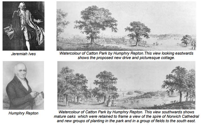
8ed D. Cubitt, A. L. Mackley and R. G. Wilson The Great Tour of John Patterson 1778-9 (Norfolk Record Society,
2003) p15
Landscaping by Humphry Repton
This associated planting was carried out to form five plantations in a block of fields to the west of
the park. These had sinewy forms, indeed one was named Fiddle Plantation. These plantations
would have been visible from the mansion which was on higher ground to the north. Repton
probably also advised on planting in the meadow known as Till's, later called the Deer Park, lying
to the east of the main park across the Spixworth Road but visually linked to it. Later evidence
would suggest that the ha-ha was not implemented, and that the new driveway and ornamental
cottage were not built until after 1794. It was not shown on the view of Catton Hall from Peacock's
Polite Repository of 1792.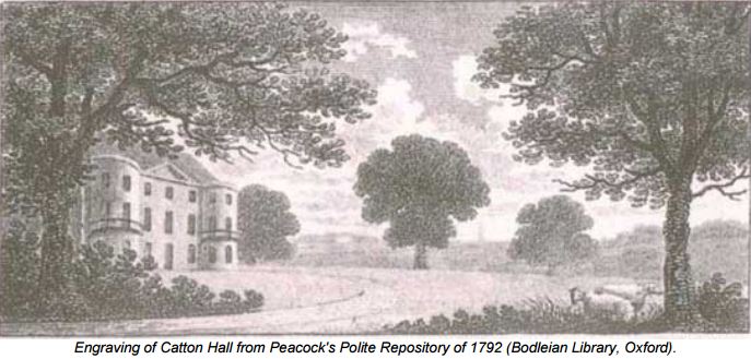 Neither do they appear on the map made by William Faden for his Survey of the County of
Norwich published in 1797, which was surveyed in 1794, which clearly shows Catton Hall and its
park and the drive from the south west but were certainly built by 1817. Faden's survey shows two
further country houses to the south of Catton Park.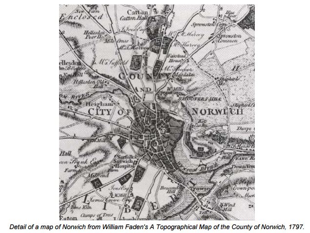 It is likely that Repton removed trees to the south of the park to give a view of the spire of Norwich
Cathedral. There is some evidence to suggest that even as late as 1801 Ives was adding land to
his Catton estate when he acquired further land and tithes.
The first Ordnance Survey Map of 1817 clearly shows the driveway from the north east had been
constructed10 together with the ornamental Gothic cottage. A map of 1819 indicated that at that
date the parkland at Catton was 43 acres and was divided into four enclosures11. On Jeremiahs
Ives' death in 1820, the Catton estate passed to his wife, Mrs Frances Ives, who lived there until
her death in 1835 when the estate was sold. The descriptions and plan of the 1835 sale
catalogue12 give a detailed picture of the estate.
10British library, Ordnance Surveyors' Drawings, 241, port.23, 1817.
11NRO BR 276/1/0488/1-2 Map of Catton Estate.
12NRO BR 276/1/218 Sale of Catalogue of the Catton Estate by W M Butcher, 8 August 1835.
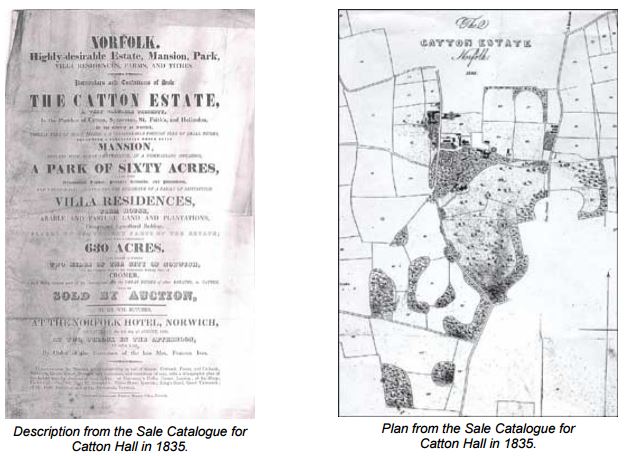
The entire Catton Hall estate extended to 630 acres of which 461 acres were in Catton, 120 acres
in Sprowston and small acreages in St Faith's and Hellesdon. The house and park were described
as 'the brick-built mansion, replete with every accommodation, placed on a handsome elevation in
a park of sixty acres'. It was also described as 'a park of sixty acres varied with ornamental timber,
pleasure grounds and plantations'.
The mansion was in nine acres of pleasure grounds whilst the park was divided into three areas,
the two sections south of the house were 21 acres and 23 acres and there was a further area of
ten acres across the road to the south west backed by the ornamental plantations one of which
was a 'beautiful hanging wood.' The walks and drives in the vicinity of the house had been
increased for in addition to the original driveway from the south-west and the Repton walk from the
Spixworth Road past the ornamental Gothic cottage, now known as Holiday House, there was a
walk or drive north from the house to the ivy covered church, and a further drive to Church Street
past the stable block. Some building had taken place with land leased for two villa residences to
the north of Catton Hall one in the occupation of Warner Wright M.D. and the other to George
Harvey, esq.
The Catton Estate was sold to Captain George Morse a Norwich brewer who was the owner in
1844 at the time of the tithe assessment. By this date the estate in Catton had been reduced to
189 acres compared with the 461 acres owned by Mrs Ives. The estate, in addition to Catton Hall
and Park, by then consisted of the land immediately adjoining the park including the meadows and
plantations to the south-west, the group of four meadows on the north side of Church Lane and
the area which later became the Deer Park. The main alteration to the landscaping made by
Morse was the creation of a path through the eastern block of woodland13.
The Catton Estate was sold again in 1852 in several lots and the major portion was purchased by
John Henry Gurney. The sale catalogue described the mansion as 'well placed on rising ground
enclosed in a remarkably beautiful picturesque park of sixty acres abiding with fine old trees and
greatly diversified with rich undulating scenery and commanding very striking and original views14.
The 1852 sale catalogue included a view from Catton Hall to the church.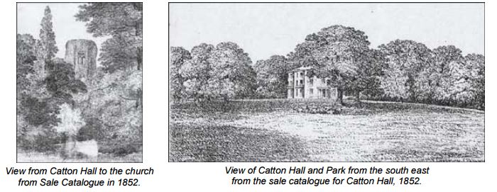
13NRO DS 49 Map from the sale catalogue of the Catton Estate by Butcher 24 September 1852.
14NRO MC 958/2 Ms draft of Catton Park sale catalogue, August 1852.
J H Gurney was a member of the prominent Norwich banking family and he made significant
landscape changes to the Catton estate, particularly to the park.
In 1856 Catton Park was again enlarged by a second road diversion to the west of the Norwich to
Catton road15. This incorporated some of the 18th century plantations to the south west and the
extent of the park was increased to seventy four acres. Considerable new planting took place in
the woodlands on the new periphery of the park to join up the existing plantations, using mainly
ornamental conifers. This resulted in an extensive belt of planting around the margins of the park,
except to the north east, with an edge planting of shrubs. A lengthy circuit path system was
introduced through the woodland, commencing at the house leading westwards and returning to
the house through the path in the eastern woodland until, after crossing the park, it joined the
north eastern driveway. On the western side a branch of the path was made that extended across
the new main road making a circuit in Fiddle wood. Whereas when the park had been created in
the third quarter of the 18th century the southern views towards Norwich were considered of
importance, seventy years later because of growth of the city, greater privacy was required.
The importance of the park was emphasised by the creation of a new lodge entrance and
driveway at its southern apex in Oak Lane leading northwards transecting the length of the park.
The entrance was made at the point where the old line of the Norwich to Catton road had met Oak
Lane and the new driveway incorporated a short section of the old road before following a route
across the enlarged park. The lodge cottage was a single story building in classical style reached
from an impressive entrance of ornamental iron gate piers and railings designed by Barnard,
Bishop and Barnard of Norwich16.
At the same time as the alterations were being made to the park J H Gurney applied for
permission to divert a footpath in an area of meadowland outside the park, but which was visually
linked to it. The order of 185817 allowed him to make a new path on the northern boundary of Till's
pasture to replace the one which had been visible from the north east section of the park. By the
late 19th century the next owner Samuel Gurney Buxton had introduced deer in this area and it
was henceforth known as the Deer Park.
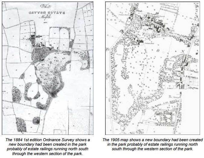
Samuel Gurney Buxton had purchased the estate from his cousin after the failure of the Gurney
bank had forced its sale. The changes to the driveways are indicated on the first edition Ordnance
Survey Map of 1884. After the creation of the new drive from the southern apex of the park in the
1850s the original driveway from the south west was abandoned and replaced by a shorter drive
from St Faith's road, and Repton's drive past the Gothic cottage was eradicated. This map also
shows part of the north western section of the park used for archery and it is known that in the late
19th century there was a cricket ground in the park to the north east of the house.
15NRO C/Sce 1 Road Order Box 20,3
16Listed Building description in Old Catton Conservation Area
17NRO C/Sce 2/10/3
In the Second World War Catton Hall was commandeered by the Army and part of the park was
ploughed up for food production, including the cricket pitch. Army training was carried out in the
park. In 1948 the northern section of the park and Catton Hall were sold by Desmond Buxton to
Norfolk County Council. Catton Hall was used as a home for the elderly and a special school, Hall
School was built in a portion of the park to the south west of the hall. The southern section of the
park was retained by the Buxton family, but large areas of the park in the ownership of Norfolk
County Council and the Buxtons have been arable production. In 1974 the remaining section of
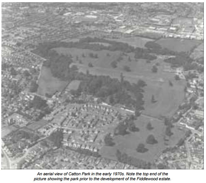
the 18th century ornamental plantations, centred on Fiddle Wood, were sold by Desmond Buxton
to Norfolk County Council and this was developed as Fiddlewood estate.